places in Quetta
Pakistan
Quetta
06:31:18
Quetta
Administrative Region:
Balochistan
population:
1 001 205
calling code:
+92-82
postcode:
87300
87500
87650
Location on the map of Pakistan
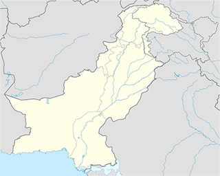
Quetta
Storage
Balochistan Oil Traders
Quetta
Storage
read more
Engro Warehouse
kahrotabad bypassQuetta
Storage
read more
Safina Cold Storage
Quetta
Storage
read more
Colgate Palmolive Warehouse
Quetta
Storage
read more
engro fertilizers warehouse
N-25, Quetta
Storage
read more
Railway Station Cargo
Quetta
Storage
read more
Airport
Helipad, CMH Quetta
Quetta
Airport
read more
Bus station
Bus Stop
Alamdar Road, Quetta
Bus station
read more
Burrak 2D Car Service Bus Stop
Quetta
Bus station
read more
Police al Muhafiz colony Quetta
87300، Quetta
Bus station
read more
Karachi Coach Terminal
Sariab Road, Quetta
Bus station
read more
Chashma Chowk Bus Stop
Quetta
Bus station
read more
Killi Almas/ Sheikhmanda Stop
Quetta
Bus station
read more
Chaman Phatak Bus Stop
Mir Jafar Khan Jamali Road, Quetta
Bus station
read more
Sadabahar Bus Terminal
Sariab Road, Quetta
Bus station
read more
Brewery Bus Stop
Quetta
Bus station
read more
Pishin Station
Quetta
Bus station
read more
Marri Abad Bus stop
toward syed garnade Bridge, Quetta
Bus station
read more
Hazara Town Station
Quetta
Bus station
read more
Bus Stop
Circular Road, Quetta
Bus station
read more
Truck & Bus Stop
Hazara Qabristan Road, Quetta
Bus station
read more
Old Pishin stop
White Road, Quetta
Bus station
read more
Car rental
Khyber 2d Car Service
Quetta
Car rental
read more
Usmania 2.0D Service
Shop No. 7, Swiss Plaza, Hali road, Quetta
Car rental
read more
Car rental
Quetta
Car rental
read more
All Pakistan Rent A Car Serivce
Quetta
Car rental
read more
Karwan 2d Car Service
Whyte Road, Quetta
Car rental
read more
BURRAK 2D CAR
Jilani Khan Road, Quetta
Car rental
read more
Colloquial area
Quetta Metropolitan Area
Pakistan
Colloquial area
read more
Quetta Cantonment
Quetta
Colloquial area
read more
Quetta District
Pakistán
Colloquial area
read more
📑
Quetta all categories
Accounting
Administrative area level 1
Airport
Art gallery
Atm
Bakery
Bank
Bar
Beauty salon
Book store
Bus station
Cafe
Campground
Car dealer
Car rental
Car repair
Car wash
Cemetery
Church
Clothing store
Colloquial area
Convenience store
Courthouse
Dentist
Department store
Doctor
Electronics store
Embassy
Finance
Fire station
Florist
Food
Furniture store
Gas station
General contractor
Grocery or supermarket
Gym
Hair care
Hardware store
Health
Hindu Temple
Home goods store
Hospital
Insurance agency
Jewelry store
Laundry
Lawyer
Library
Local government office
Locality
Lodging
Meal delivery
Meal takeaway
Mosque
Movie rental
Movie theater
Museum
Natural feature
Neighborhood
Night club
Painter
Park
Parking
Pet store
Pharmacy
Place of worship
Point of interest
Police
Political
Post office
Premise
Real estate agency
Restaurant
Route
School
Shoe store
Shopping mall
Spa
Stadium
Storage
Store
Supermarket
Taxi stand
Train station
Travel agency
University
Veterinary care
sublocality level 1
sublocality level 2
↑