Police nearby National Highway & Motorway Police
Pakistan
Police nearby National Highway & Motorway Police
National Highway & Motorway Police
H-8-2, H-8, Islamabad, ICT Pakistán
contacts phone
:
+92
Latitude:
33.68374
, Longitude:
73.0614
read more
nearest Police
National Highway & Motorway Police Office
H-8-2, H-8, Islamabad, ICT
Police
read more
1.328 km
Trafic Police Zone
فیصل ایونیو, Islamabad
Police
read more
1.558 km
Police Check Post
Kashmir Highway, Islamabad
Police
read more
1.761 km
Rescue 15
Service Road East, Islamabad
Police
read more
1.763 km
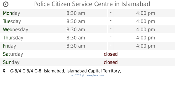
Police Citizen Service Centre
Islamabad
Police
read more
1.782 km
G-8 Community Police center
Islamabad
Police
read more
2.348 km
Police Station Special Branch
G 7 Markaz
Police
read more
2.49 km
Women Police Station
Islamabad
Police
read more
2.539 km
G-9 Police Station
Islamabad
Police
read more
2.569 km
Model Police Station Industrial Area I-9
Potohar Metro Overpass, Islamabad
Police
read more
2.569 km
Industrial Area I-9 Police Station
Potohar Metro Overpass, Islamabad
Police
read more
2.891 km
CIA Police Station
I-9-3, I-9, Islamabad, ICT
Police
read more
2.954 km
Traffic police zone 2
Karachi Company, Islamabad
Police
read more
3.044 km
Police Station
Tipu Sultan Road, Islamabad
Police
read more
3.068 km
ITP Office
Benazir Bhutto Road, Islamabad
Police
read more
3.068 km
ITP Office
Murree Road, Islamabad
Police
read more
3.44 km
Margalla Police Station
Kaghan Road, Islamabad
Police
read more
3.68 km
Islamabad Traffic Police Headquarters
F-8-1, F-8, Islamabad, ICT
Police
read more
3.967 km
National Police Bureau
Municipal Road, G-6 Markaz, Islamabad
Police
read more
4.266 km
I-10 Community Police Center
Sohni Road, Islamabad
Police
read more
4.324 km
Aabpara Police Station
Municipal Road, Islamabad
Police
read more
4.336 km
MPS AABPARA
G-6 Markaz
Police
read more
4.351 km
SSP Office Islamabad
G-10 Markaz, Islamabad
Police
read more
5.05 km
Special Branch
Service Road East, Islamabad
Police
read more
6.435 km
Secretariat Police Station
Isfahani Road, Islamabad
Police
read more
📑
all categories
Accounting
Administrative area level 1
Administrative area level 2
Airport
Amusement park
Aquarium
Art gallery
Atm
Bakery
Bank
Bar
Beauty salon
Bicycle store
Book store
Bowling alley
Bus station
Cafe
Campground
Car dealer
Car rental
Car repair
Car wash
Casino
Cemetery
Church
City hall
Clothing store
Colloquial area
Convenience store
Courthouse
Dentist
Department store
Doctor
Electrician
Electronics store
Embassy
Finance
Fire station
Florist
Food
Funeral home
Furniture store
Gas station
General contractor
Grocery or supermarket
Gym
Hair care
Hardware store
Health
Hindu Temple
Home goods store
Hospital
Insurance agency
Intersection
Jewelry store
Laundry
Lawyer
Library
Light rail station
Liquor store
Local government office
Locality
Locksmith
Lodging
Meal delivery
Meal takeaway
Mosque
Movie rental
Movie theater
Moving company
Museum
Natural feature
Neighborhood
Night club
Painter
Park
Parking
Pet store
Pharmacy
Physiotherapist
Place of worship
Plumber
Point of interest
Police
Political
Post office
Premise
Real estate agency
Restaurant
Roofing contractor
Route
Rv park, camping
School
Shoe store
Shopping mall
Spa
Stadium
Storage
Store
Sublocality
Subway station
Supermarket
Taxi stand
Train station
Transit station
Travel agency
University
Veterinary care
Zoo
administrative area level 3
sublocality level 1
sublocality level 2
sublocality level 3
↑