places in Nawabshah
Pakistan
Nawabshah
Nawabshah
Administrative Region:
Sindh
population:
279 688
calling code:
+92-241
postcode:
67450
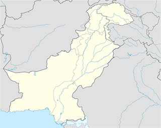
Location on the map of Pakistan
Nawabshah
Parking
Parking For Cars
Nawabshah
Parking
read more
Parking Area
Shaheed Benazir Bhutto University, Nawabshah
Parking
read more
Bus/Point Parking
Nawabshah
Parking
read more
Airport
Nawabshah Airport
Airport Rd, Shaheed Benazir Abad
Airport
read more
Hospital
Syed Medical Center
Sakrand Road, Shaheed Benazir Abad
Hospital
read more
Furzana Clinic
Nawabshah
Hospital
read more
شفا شوگر کلینک ۔نواب شاہ
Eid Gah Road, Nawabshah
Hospital
read more
Shahbaz Medical Centre
Nawabshah
Hospital
read more
Mastoi Hospital
Civil Hospital Road, Nawabshah
Hospital
read more
Chandca Poly Clinic
Nawabshah
Hospital
read more
New Jinnah Medical Center
Sakrand Road, Nawabshah
Hospital
read more
Hira Clinic
Nawabshah
Hospital
read more
Nawabshah Medical Hospital
Nawabshah
Hospital
read more
Dr Idress Memon
Nawabshah
Hospital
read more
Qureshi Welfere Center قریشی ویلفئر سینٹر
a23 Shihbaz Road, Nawabshah
Hospital
read more
Shanza Electro NeuroPhysiology Diagnostic Center
Opposite PMC hospital main gate, Nawabshah
Hospital
read more
Fazan e Aam Dawakhana
Nawabshah
Hospital
read more
At Zoaib Medicare Society
Society Road, Nawabshah
Hospital
read more
Rehman Medical Center
pmch hospital road, Nawabshah
Hospital
read more
Laundry
New White Dry Cleaner
Daudi Chowk Link Road, Sindh
Laundry
read more
Library
CPSP Library Nawabshah
Nawabshah
Library
read more
HM Khoja Memorial Library
Civil Hospital Road, Shaheed Benazir Abad
Library
read more
Central Library
Nawabshah
Library
read more
Central Library PUMHSW Nawabshah
Peoples University of Medical & Health Sciences for Women, Shaheed Benazirabad
Library
read more
Central Library SBBU
Nawabshah
Library
read more
📑
Nawabshah all categories
Accounting
Administrative area level 2
Airport
Art gallery
Atm
Bakery
Bank
Beauty salon
Book store
Bus station
Cafe
Car dealer
Car repair
Cemetery
City hall
Clothing store
Colloquial area
Courthouse
Dentist
Doctor
Electronics store
Finance
Fire station
Food
Furniture store
Gas station
General contractor
Grocery or supermarket
Gym
Health
Home goods store
Hospital
Insurance agency
Jewelry store
Laundry
Lawyer
Library
Local government office
Locality
Lodging
Mosque
Movie theater
Museum
Natural feature
Neighborhood
Night club
Park
Parking
Pharmacy
Place of worship
Point of interest
Police
Post office
Premise
Real estate agency
Restaurant
Route
School
Shoe store
Shopping mall
Stadium
Storage
Store
Supermarket
Taxi stand
Train station
Transit station
Travel agency
University
Veterinary care
administrative area level 3
sublocality level 1
↑