Lodging nearby PPMI Hostel
Pakistan
Lodging nearby PPMI Hostel
PPMI Hostel
H-8/1 H 8/1 H-8, Islamabad, Islamabad Capital Territory, Pakistan
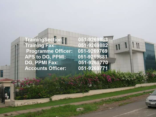
contacts phone
:
+92
Latitude:
33.6764678
, Longitude:
73.0616211
larger map & directions
read more
nearest Lodging
294 m
ICCC Hostel
Islamabad
Lodging
read more
329 m
Chashnupp Hostel
Islamabad
Lodging
read more
436 m
NISTE HOSTEL
Islamabad
Lodging
read more
658 m
Bismillah Hotel(dhaba)
Islamabad
Lodging
read more
689 m
Alain Residency Near Shifa Hospital
House # 46-B, #, Street 39, Islamabad
Lodging
read more
696 m
STI (Survey Training Institute) Hostel ایس ٹی آئی ہوسٹل
Islamabad
Lodging
read more
725 m
Rare Hostel
house 46 b, Street 39, Islamabad
Lodging
read more
737 m
Students Shelter Girls Hostel
House 417-D, Street 37, Islamabad
Lodging
read more
749 m
Islamabad Hostel
street 36 house 421 , I-8/2, Islamabad
Lodging
read more
783 m
Wateen Guest House
Islamabad
Lodging
read more
784 m
PMD Residential Colony
Islamabad
Lodging
read more
803 m
Hostels AIOU
Allama Iqbal Open University, Islamabad
Lodging
read more
838 m
Shalimar Boys Hostel
Street 38, Islamabad
Lodging
read more
838 m
Shalimar Boys Hostel
Street 36, Islamabad
Lodging
read more
894 m
Railway Rest House
H-8-2, H-8, Islamabad, ICT
Lodging
read more
896 m
chapar hotel 2
Islamabad
Lodging
read more
994 m
Information Service Group Hostel
Kirthar Road, Islamabad
Lodging
read more
1.744 km
Boys Hostel
Islamabad
Lodging
read more
1.778 km
Ballagio Hotel
Islamabad
Lodging
read more
1.797 km
Shani Boys Hostel
plot#16, 4 Street 22, Islamabad
Lodging
read more
1.846 km
Glaxay Boys Hostel
Islamabad
Lodging
read more
1.989 km
Islamabad City Hotel
2-E, I-9 Markaz, I-9, Islamabad, ICT
Lodging
read more
2.24 km
T and F Girls Hostel
Islamabad
Lodging
read more
2.461 km
Al Hateem Palace Hotel
I.J.P. Road, Islamabad
Lodging
read more
2.618 km
Green Land Hotel
Faizabad Road, Rawalpindi
Lodging
read more
📑
all categories
Accounting
Administrative area level 1
Administrative area level 2
Airport
Amusement park
Aquarium
Art gallery
Atm
Bakery
Bank
Bar
Beauty salon
Bicycle store
Book store
Bowling alley
Bus station
Cafe
Campground
Car dealer
Car rental
Car repair
Car wash
Casino
Cemetery
Church
City hall
Clothing store
Colloquial area
Convenience store
Courthouse
Dentist
Department store
Doctor
Electrician
Electronics store
Embassy
Finance
Fire station
Florist
Food
Funeral home
Furniture store
Gas station
General contractor
Grocery or supermarket
Gym
Hair care
Hardware store
Health
Hindu Temple
Home goods store
Hospital
Insurance agency
Intersection
Jewelry store
Laundry
Lawyer
Library
Light rail station
Liquor store
Local government office
Locality
Locksmith
Lodging
Meal delivery
Meal takeaway
Mosque
Movie rental
Movie theater
Moving company
Museum
Natural feature
Neighborhood
Night club
Painter
Park
Parking
Pet store
Pharmacy
Physiotherapist
Place of worship
Plumber
Point of interest
Police
Political
Post office
Premise
Real estate agency
Restaurant
Roofing contractor
Route
Rv park, camping
School
Shoe store
Shopping mall
Spa
Stadium
Storage
Store
Sublocality
Subway station
Supermarket
Taxi stand
Train station
Transit station
Travel agency
University
Veterinary care
Zoo
administrative area level 3
sublocality level 1
sublocality level 2
sublocality level 3
↑