Hospital nearby Prime Hospital Complex
Pakistan
Hospital nearby Prime Hospital Complex
Prime Hospital Complex
Warsak Road, Peshawar Pakistan
contacts phone
:
+92
Latitude:
34.0369819
, Longitude:
71.5302943
read more
nearest Hospital
628 m
DUA Medical Laboratory
Warsak Road near Peshawar Medical College Malik Qayyum Plaza Peshawar, Warsak Michini Rd, Peshawar
Hospital
read more
713 m
Mother And Child Health Clinic
near khushal bagh, Warsak Road, Peshawar
Hospital
read more
1.163 km
Terai Payan BHU
Peshawar
Hospital
read more
1.359 km
Babar Clinic
Darmangi
Hospital
read more
1.654 km
Irrigation Colony CD
Peshawar
Hospital
read more
1.81 km
Shah Sons Medical Centre
Peshawar
Hospital
read more
2.021 km
BHU Faqeer Kalay
Faqeer Kalay Chowk, Khyber Pakhtoonkhwa, Pajaggi Road, Peshawar
Hospital
read more
2.021 km
Al Shifa Maternity Home
Peshawar
Hospital
read more
2.049 km
Ali Medical Centre
Warsak Road, Darmangi
Hospital
read more
2.096 km
Noor Medical Center
Warsak Road, Darmangi
Hospital
read more
2.479 km
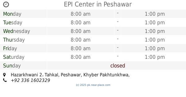
EPI Center
Hazarkhwani 2
Hospital
read more
2.589 km
Federal Hospital Hassan ghari
Street 2, Street 2 Shami Road, Peshawar
Hospital
read more
2.725 km
Farzan Khan Mardan Clinic
Peshawar
Hospital
read more
2.732 km
Tahira Nasreen Clinic
Peshawar
Hospital
read more
2.866 km
Lady Reading Hospital
Peshawar
Hospital
read more
2.921 km
WAPDA Hospital
Peshawar
Hospital
read more
3.056 km
Farhana Rahim Clinic
Peshawar
Hospital
read more
3.092 km
FWC, Tehkal Bala
Chalmaray Road, Peshawar
Hospital
read more
3.136 km
Shaheen Iftikhar Clinic
Peshawar
Hospital
read more
3.304 km
Basic Health Unit Mandrakhel Peshawer
Pakistan
Hospital
read more
3.666 km
Police Services Hospital
Police Lines Road, Peshawar
Hospital
read more
3.666 km
New Services Hospital
Police Lines Road, Peshawar
Hospital
read more
4.455 km
MEEZAN MRI
Peshawar
Hospital
read more
4.747 km
Department of Pulmonology
LRH Hospital, Hakeem Ullah Jan Road,, Peshawar
Hospital
read more
5.794 km
Peshawar Health Centre
Peshawar
Hospital
read more
📑
all categories
Accounting
Administrative area level 1
Administrative area level 2
Airport
Amusement park
Aquarium
Art gallery
Atm
Bakery
Bank
Bar
Beauty salon
Bicycle store
Book store
Bowling alley
Bus station
Cafe
Campground
Car dealer
Car rental
Car repair
Car wash
Casino
Cemetery
Church
City hall
Clothing store
Colloquial area
Convenience store
Courthouse
Dentist
Department store
Doctor
Electrician
Electronics store
Embassy
Finance
Fire station
Florist
Food
Funeral home
Furniture store
Gas station
General contractor
Grocery or supermarket
Gym
Hair care
Hardware store
Health
Hindu Temple
Home goods store
Hospital
Insurance agency
Intersection
Jewelry store
Laundry
Lawyer
Library
Light rail station
Liquor store
Local government office
Locality
Locksmith
Lodging
Meal delivery
Meal takeaway
Mosque
Movie rental
Movie theater
Moving company
Museum
Natural feature
Neighborhood
Night club
Painter
Park
Parking
Pet store
Pharmacy
Physiotherapist
Place of worship
Plumber
Point of interest
Police
Political
Post office
Premise
Real estate agency
Restaurant
Roofing contractor
Route
Rv park, camping
School
Shoe store
Shopping mall
Spa
Stadium
Storage
Store
Sublocality
Subway station
Supermarket
Taxi stand
Train station
Transit station
Travel agency
University
Veterinary care
Zoo
administrative area level 3
sublocality level 1
sublocality level 2
sublocality level 3
↑