Hospital nearby Haris Medical Complex
Pakistan
Hospital nearby Haris Medical Complex
Haris Medical Complex
Ehtsham Colony Ehtesham Colony, Gujranwala, Punjab, Pakistán
contacts phone
:
+92
Latitude:
32.1849176
, Longitude:
74.1886284
larger map & directions
read more
nearest Hospital
12 m
Haris Medical Complex
underpass chowk sui gas road
Hospital
read more
55 m
Janjua Physcial Therapy Clinic
jinah road shamshi chowk, Gujranwala
Hospital
read more
173 m
Alfalak Diagnostic Center
DC Road, Gujranwala
Hospital
read more
391 m
Adil Hospital
DC Road, Gujranwala
Hospital
read more
391 m
Taj Memorial Eye
DC Road, Gujranwala
Hospital
read more
515 m
Hamail Clinic
Gujranwala
Hospital
read more
696 m
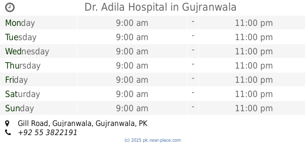
Dr. Adila Hospital
Gill Road, Gujranwala
Hospital
read more
710 m
Gulzar hospital
Dastgir Street, Gujranwala
Hospital
read more
801 m
Edhi Center
Service Road, Gujranwala
Hospital
read more
859 m
Yasir Homeo Family Clinic
Gujranwala
Hospital
read more
880 m
Masoom Ali Siddiqi Clinic
Gujranwala
Hospital
read more
884 m
Dr. Naseem Ahmad Saeed
24, Gujranwala
Hospital
read more
885 m
Medcare International Hospital
Civil Lines, Gill Road, Gujranwala
Hospital
read more
890 m
Amina Fatima Clinic
Gujranwala
Hospital
read more
915 m
Shifa Lab Collection Center Gujranwala
opposite Med Care Hopital, Gill Road, Gujranwala
Hospital
read more
982 m
Dr. Zafar Chaudhari & Dr. Sonia Chaudhari
Gujranwala
Hospital
read more
1.023 km
Naeem Hospital D.C road gujranwala
Naeem Hospital D.C road, Gujranwala
Hospital
read more
1.04 km
Azeez Poly Clinic
Gujranwala
Hospital
read more
1.109 km
Government Social Security Hospital Gujranwala
Gujranwala
Hospital
read more
1.137 km
City Ortho & Medical Hospital ڈاکٹر مظفرنصراللہ چٹھہ
DC Road, Gujranwala
Hospital
read more
1.14 km
City Hospital
Gujranwala
Hospital
read more
1.16 km
Ali Clinic
Gujranwala
Hospital
read more
1.284 km
Govt Social Security Hospital.Model Town Grw
Model Town Rd, Model Town, Gujranwala
Hospital
read more
1.729 km
Munir Medical Complex
Hospital Road, Munir Chowk, Gujranwala
Hospital
read more
2.009 km
Raheela Research Lab (Collection)
Gujranwala
Hospital
read more
📑
all categories
Accounting
Administrative area level 1
Administrative area level 2
Airport
Amusement park
Aquarium
Art gallery
Atm
Bakery
Bank
Bar
Beauty salon
Bicycle store
Book store
Bowling alley
Bus station
Cafe
Campground
Car dealer
Car rental
Car repair
Car wash
Casino
Cemetery
Church
City hall
Clothing store
Colloquial area
Convenience store
Courthouse
Dentist
Department store
Doctor
Electrician
Electronics store
Embassy
Finance
Fire station
Florist
Food
Funeral home
Furniture store
Gas station
General contractor
Grocery or supermarket
Gym
Hair care
Hardware store
Health
Hindu Temple
Home goods store
Hospital
Insurance agency
Intersection
Jewelry store
Laundry
Lawyer
Library
Light rail station
Liquor store
Local government office
Locality
Locksmith
Lodging
Meal delivery
Meal takeaway
Mosque
Movie rental
Movie theater
Moving company
Museum
Natural feature
Neighborhood
Night club
Painter
Park
Parking
Pet store
Pharmacy
Physiotherapist
Place of worship
Plumber
Point of interest
Police
Political
Post office
Premise
Real estate agency
Restaurant
Roofing contractor
Route
Rv park, camping
School
Shoe store
Shopping mall
Spa
Stadium
Storage
Store
Sublocality
Subway station
Supermarket
Taxi stand
Train station
Transit station
Travel agency
University
Veterinary care
Zoo
administrative area level 3
sublocality level 1
sublocality level 2
sublocality level 3
↑