Store nearby Bashir Cloth House
Coronavirus disease (COVID-19) Situation
confirmed cases
1581936
deaths
30664
Pakistan
Store nearby Bashir Cloth House
Bashir Cloth House
Jaranwala, Faisalabad, Punjab, Pakistan
contacts phone
:
+92 300 6531967
Latitude:
31.3362639
, Longitude:
73.4220278
larger map & directions
read more
Most popular categories:
Administrative area level 2
Sheikhupura
Pakistan
Administrative area level 2
read more
Bannu
Pakistan
Administrative area level 2
read more
Abbottabad
Pakistan
Administrative area level 2
read more
Khuzdar
Pakistan
Administrative area level 2
read more
Peshawar
Pakistan
Administrative area level 2
read more
Bahawalnagar
Pakistan
Administrative area level 2
read more
Haripur
Pakistan
Administrative area level 2
read more
Kohat
Pakistan
Administrative area level 2
read more
Dystrykt Peszawar
Pakistan
Administrative area level 2
read more
Rahim Yar Khan
Pakistan
Administrative area level 2
read more
Gujranwala
Pakistan
Administrative area level 2
read more
Sukkur
Pakistan
Administrative area level 2
read more
Rawalpindi
Pakistan
Administrative area level 2
read more
Hyderabad
Pakistan
Administrative area level 2
read more
Kech
Pakistan
Administrative area level 2
read more
Shaheed Benazirabad
Pakistan
Administrative area level 2
read more
Lahore
Pakistan
Administrative area level 2
read more
Tando Allah Yar
Pakistan
Administrative area level 2
read more
Karachi City
Pakistan
Administrative area level 2
read more
Dystrykt Hajdarabad
Pakistan
Administrative area level 2
read more
Quetta
Pakistan
Administrative area level 2
read more
Multan
Pakistan
Administrative area level 2
read more
Chiniot
Pakistan
Administrative area level 2
read more
Toba Tek Singh District
Pakistan
Administrative area level 2
read more
Jhelum
Pakistan
Administrative area level 2
read more
administrative area level 4
Airport
Peshawar International Airport
Airport Road, Peshawar
Airport
read more
Kohat Airport
Hangu Bypass, Kohat
Airport
read more
Aéroport International De Peshawar (PEW)
Khyber Road, Peshawar
Airport
read more
Dera Ismail Khan Airport
10 km away from the city centre of Dera Ismail Khan, Bannu Road, Shorkot
Airport
read more
Port lotniczy Bahawalpur
Airport Road, Bahawalpur
Airport
read more
Allama Iqbal International Airport Lhr
Airport Road, Lahore
Airport
read more
Hajj Terminal Allama Iqbal International Airport
Lahore
Airport
read more
Saidu Sharif Airport
near the Swat River, Airport Road, Kanju
Airport
read more
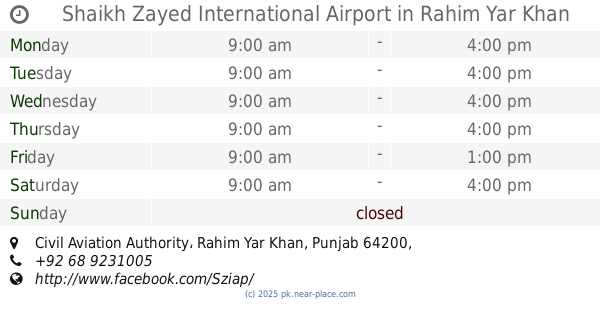
Shaikh Zayed International Airport
Civil Aviation Authority, Rahim Yar Khan
Airport
read more
Heliport and car park
Mardan
Airport
read more
State Lounge Allama Iqbal International Airport
Lahore
Airport
read more
East Terminal
Arrivals / Short Stay, Lahore
Airport
read more
Burewala Helipad
Sabza Zar Housing Scheme, Burewala
Airport
read more
AIIAP Lhr
Airport Road, Lahore
Airport
read more
Nawabshah Airport
Airport Rd, Shaheed Benazir Abad
Airport
read more
Sheikh Rashid Terminal
Bahawalpur
Airport
read more
Allama Iqbal International Airport
Airport Road, Lahore
Airport
read more
Scaled Aviation Industries (Private) Limited
Walton Airport, Royal Hangar,, Lahore
Airport
read more
Bahawalpur Airport (BHV)
Airport Road, Bahawalpur
Airport
read more
Jhelum Cantt Helipad
Jhelum
Airport
read more
Walton Airport
Lahore
Airport
read more
Helipad
Indus Highway, Larkana
Airport
read more
Cantonment Helipad
Cantoment Park Ave, Hyderabad
Airport
read more
Khuzdar Heliport
University Road, Khuzdar
Airport
read more
M M Alim Airport Khuzdar
Airport Road, Khuzdar
Airport
read more
📑
all categories
Accounting
Administrative area level 1
Administrative area level 2
Airport
Amusement park
Aquarium
Art gallery
Atm
Bakery
Bank
Bar
Beauty salon
Bicycle store
Book store
Bowling alley
Bus station
Cafe
Campground
Car dealer
Car rental
Car repair
Car wash
Casino
Cemetery
Church
City hall
Clothing store
Colloquial area
Convenience store
Courthouse
Dentist
Department store
Doctor
Electrician
Electronics store
Embassy
Finance
Fire station
Florist
Food
Funeral home
Furniture store
Gas station
General contractor
Grocery or supermarket
Gym
Hair care
Hardware store
Health
Hindu Temple
Home goods store
Hospital
Insurance agency
Intersection
Jewelry store
Laundry
Lawyer
Library
Light rail station
Liquor store
Local government office
Locality
Locksmith
Lodging
Meal delivery
Meal takeaway
Mosque
Movie rental
Movie theater
Moving company
Museum
Natural feature
Neighborhood
Night club
Painter
Park
Parking
Pet store
Pharmacy
Physiotherapist
Place of worship
Plumber
Point of interest
Police
Political
Post office
Premise
Real estate agency
Restaurant
Roofing contractor
Route
Rv park, camping
School
Shoe store
Shopping mall
Spa
Stadium
Storage
Store
Sublocality
Subway station
Supermarket
Taxi stand
Train station
Transit station
Travel agency
University
Veterinary care
Zoo
administrative area level 3
sublocality level 1
sublocality level 2
sublocality level 3
↑